Jeppesen FliteDeck Pro now includes high-level significant weather
Flight operations in the upper regions of the troposphere present unique challenges to flight crews. Operating at high altitudes demands heightened situational awareness, precise planning, and the ability to adapt rapidly to potential hazards. To help improve high-altitude awareness and decision-making, we now provide a high-level significant weather layer in Jeppesen FliteDeck Pro 5.2.
By integrating this–plus several other comprehensive meteorological data sources–directly into FliteDeck Pro, your flight crews are empowered with the tools they need to successfully execute operations, maintain safety parameters, and optimize fuel efficiency.
The new high-altitude significant weather layer helps improve high-altitude awareness and decision making.
The challenges of high-altitude flight operations
Navigating the upper troposphere and the lower stratosphere requires pilots to manage a highly dynamic environment. At these altitudes, weather phenomena can develop rapidly and often without visual warnings. Flight crews must constantly monitor for clear air turbulence, deep convective systems, and severe icing conditions that can affect aircraft performance and passenger safety.
Without precise meteorological data, crews are forced to rely on reactive measures rather than proactive route management. Reactive weather avoidance can lead to excessive fuel burn, schedule disruptions, and increased wear on aviation assets. Furthermore, the workload associated with parsing text-based weather reports or referencing separate applications detracts from primary flight duties.
Flight crews need digital solutions that improve efficiency and streamline processes. The integration of high-level significant weather directly into the EFB addresses these challenges head-on, providing a unified operating picture that supports immediate, informed decision-making.
Comprehensive high-altitude weather data
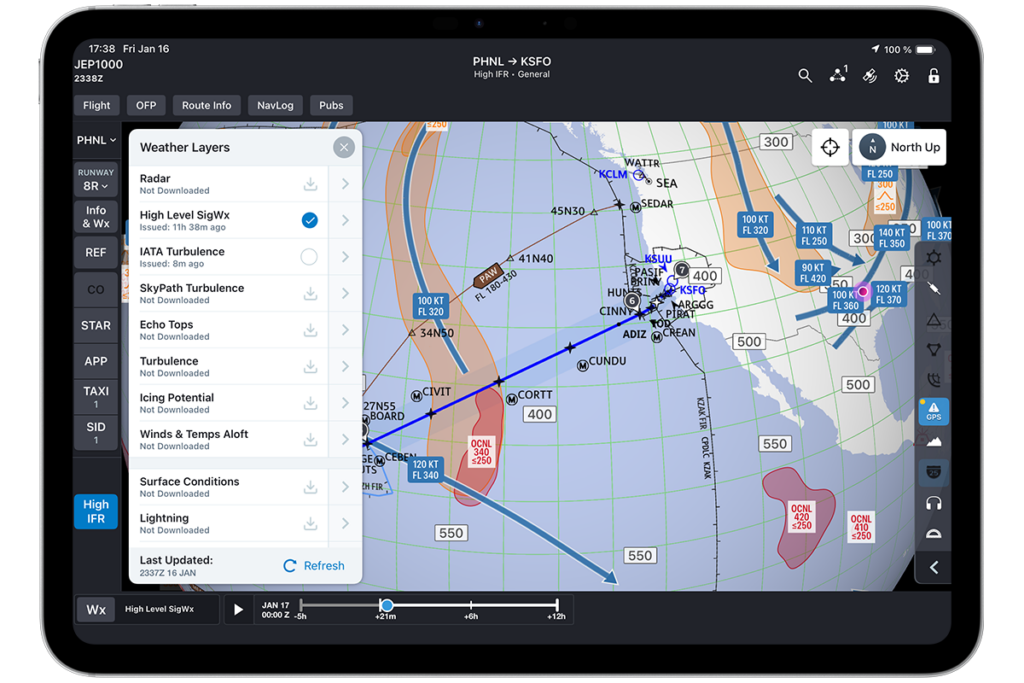
The new high-level significant weather layer is designed to give pilots a clear, geographical representation of potential atmospheric hazards. Accessible directly from the enroute map, this feature overlays critical data, allowing crews to visualize weather systems in relation to their planned flight path.
The layer includes detailed forecasts for four primary meteorological factors:
Areas of icing: By visualizing these areas, crews can proactively request altitude changes or route deviations to avoid prolonged exposure, thereby maintaining aircraft performance and safety margins.
Turbulence: High-altitude turbulence, particularly Clear Air Turbulence (CAT), is a leading cause of in-flight injuries and can cause structural fatigue over time. The turbulence layer maps forecast areas of atmospheric instability. This allows crews to anticipate rough air, secure the cabin well in advance, and negotiate altitude adjustments with Air Traffic Control to ensure a smooth and safe flight profile.
Jet streams: Understanding the precise location, core speed, and direction of jet streams is critical for optimizing flight performance. The high-level significant weather layer depicts jet stream axes and velocities. Flight crews can leverage this data to maximize tailwinds or minimize headwinds, significantly improving fuel efficiency and reducing flight times.
Tropopause heights: The height of the tropopause fluctuates based on latitude and weather systems, acting as a boundary that traps moisture and weather activity. Knowing the tropopause height helps crews anticipate the vertical extent of significant weather and determine the most efficient cruising altitudes. This data is essential for optimizing the aircraft’s performance envelope.
Data Integrity and Reliability: Powered by WSI
The primary data source for the high-level significant weather layer is Weather Services International (WSI), a globally recognized leader in aviation weather forecasting. By partnering with WSI, we ensure that flight crews receive the most precise and authoritative meteorological information available.
To maintain the highest level of accuracy, the data is updated every six hours. The weather data expires after 14.5 hours and is automatically removed from the device when the data becomes 36 hours old. This automated data management process ensures that pilots are never misled by stale meteorological data, thereby preserving the integrity of their situational awareness.
The details sheet provides a selection for auto updates, and a legend for the various symbols.
Intuitive user interface for streamlined workflows
The design of the high-level significant weather layer prioritizes ease-of-use and rapid understanding of the data thanks to the intuitive graphical elements. The user interface within FliteDeck Pro 5.2 has been optimized to deliver critical weather data without adding complexity to the pilot’s workflow.
The new weather layer is easily accessible from the primary Wx button located on the main application toolbar. With a single tap, pilots can toggle the high-level significant weather overlay on or off, instantly enriching their enroute map with vital meteorological context.
Pilots can tap the chevron next to “High Level SigWx” to open a dedicated details sheet. This menu provides additional functionality for selecting Auto Updates, and a legend for the various symbols used for icing, turbulence, jet streams, and tropopause heights.