IFR Hi/Lo Raster Enroute & VFR Sectional Charts
We now offer Garmin IFR Hi / Lo Raster Enroute Charts and VFR Sectional Charts for Garmin avionics.
Multi-Functional Displays can be supplemented with georeferenced VFR Sectional and IFR Enroute charts. An electronic database containing maps that include the depiction of low altitude LF/MF and VHF airways and mileages, navigation facilities, airports, special use airspace areas, cities, time zones and airspace classification.
Currently supported avionic units:
G1000 Nxi
G1000H Nxi
Perspective + (Cirrus)
G3000
G5000
G3X Touch
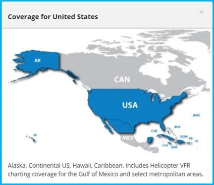
Coverages: Currently “United States,” which covers more than the political entity “USA”:
This type of service is available:
- As stand-alone service
- As part of our Garmin PilotPak Bundles
If you are interested in these offerings, please contact us at fra-services@jeppesen.com
We now offer Garmin IFR Hi / Lo Raster Enroute Charts and VFR Sectional Charts for Garmin avionics.
Multi-Functional Displays can be supplemented with georeferenced VFR Sectional and IFR Enroute charts. An electronic database containing maps that include the depiction of low altitude LF/MF and VHF airways and mileages, navigation facilities, airports, special use airspace areas, cities, time zones and airspace classification.
Currently supported avionic units:
G1000 Nxi
G1000H Nxi
Perspective + (Cirrus)
G3000
G5000
G3X Touch
Coverages: Currently “United States,” which covers more than the political entity “USA”:
This type of service is available:
- As stand-alone service
- As part of our Garmin PilotPak Bundles
If you are interested in these offerings, please contact us at fra-services@jeppesen.com