September 2020 marks the 80th anniversary of the start of the Blitz during World War II. The Battle of Britain had been raging since July 1940. In retaliation for a Royal Air Force (RAF) raid on Berlin and hoping to destroy British willpower once and for all, the Luftwaffe launched its first major bombing of London on the afternoon of Saturday, September 7, 1940. In the face of staunch (and radar-directed) resistance by RAF fighters during the day, the Luftwaffe soon transitioned to nighttime raids and embraced the cover of darkness.
The Blitz caused significant damage to London (darker colors indicate worse damage in the map) and more than 13,000 Londoners lost their lives during the height of the Blitz between September 7 and December 31, 1940. (Map sourced from the Layers of London project, here compiling the London County Council Bomb Damage Maps. The map is interactive if you want to explore bombing damage or other historical overlays of the city: https://www.layersoflondon.org/)
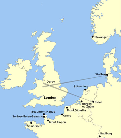
Denied the use of landmarks visible during the day, the Luftwaffe developed a system of Knickebein transmitters to guide bombers to their targets over London. Knickebein (literally “crooked leg”) was based on Lorenz beams, the first fully-operative instrument landing system (ILS) in the world, which was installed at Berlin-Tempelhof Airport in 1932. Knickebein used pairs of powerful transmitters whose beams intersected over the desired target. Luftwaffe bombers would follow the first beam toward the target and release their bombs when they crossed the second beam. Of course, the RAF soon caught on and developed electronic countermeasures, leading the Luftwaffe to create a series of increasingly advanced guidance systems in a dual known as the “Battle of the Beams.”
The first Knickebein transmitters were set up at Stollberg and Kleve (Cleves). After the fall of France in June 1940, additional transmitters were installed on the French coast. (https://en.wikipedia.org/wiki/Battle_of_the_Beams#Knickebein)
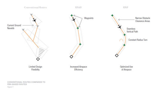
We’ve come a long way in navigation since the Second World War, but ground-based radio navigation remained the standard for many years. From the mid-1940s until the turn of the 21st century, ground-based Very High Frequency Omnidirectional Range (VOR), Distance Measuring Equipment (DME), and Non-Directional Beacon (NDB) were the primary navigation aids used by pilots. Reliance on ground-based navigation aid limits the availability of routes, forcing pilots to fly a zigzag pattern from one station to the next, which is time consuming and inefficient.
By the 1980s, aircraft began to incorporate Flight Management Systems and computers with navigation sensors which could work with VOR and DME to calculate a route between any two points without the aircraft flying directly over fixed stations on the ground. But such Area Navigation (RNAV) still restricted routes to intermediate waypoints.
Today, GPS is freeing flight paths from ground-based navigation aids, allowing much greater flexibility in flying. Incorporated into multi-sensor navigation systems or used on its own, GPS has led to the creation of Required Navigation Performance (RNP). RNP builds on RNAV and is a statement of the navigational performance necessary to operate within a defined space. The aircraft relies on its own internal positioning systems to know where it is in space at all times. Software then guides the aircraft along a very precise route independent of ground-based navigation stations.
RNP allows for optimized routing compared to ground-based navigational aids and RNAV.
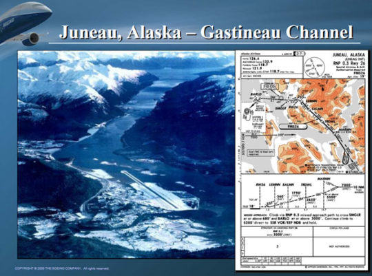
RNP has a number of applications, including allowing for more efficient approaches. Alaska Airlines developed the first RNP approach in 1996 to allow for more reliable service into Juneau, AK, where wind and poor visibility frequently rendered the traditional approach from the north difficult or impossible. Aircraft can now approach from the south through the narrow Gastineau Channel.
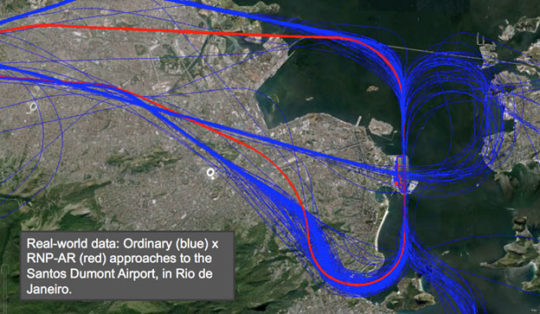
RNP approaches allow for smooth continuous descent along a curvilinear flight path rather than the head-on stair step descents required by traditional ILS. They also tend to be shorter than ILS-based approaches and increase reliability in poor weather conditions. As such, RNP-enabled descents are more fuel efficient – reducing emissions and saving airlines money – and can help avoid heavily populated, noise-sensitive areas near the flight path. They also allow a greater number of aircraft to operate safely in constrained airspace since each knows more precisely its own location.
Landings in Rio de Janeiro. Blue shows approaches using traditional navigation and red shows those done with RNP. You can see how much more precise RNP navigation is. (https://arstechnica.com/science/2015/07/saving-fuel-with-software/)
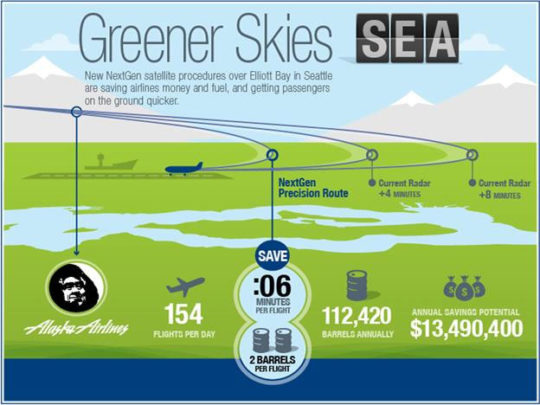
Recognizing these benefits, the FAA has published more than 9,600 Performance-Based Navigation (PBN) routes and departure, arrival, and approach procedures (including both RNAV and RNP) for more than 500 airports as part of its Next Generation Air Transportation System program (learn more at: https://www.faa.gov/nextgen/). The benefits are tangible. In 2014, Alaska Airlines reported that new RNP procedures for SeaTac saved 17 miles over previous approaches and an estimated 44 gallons of fuel per flight – roughly 1.3 million gallons of fuel per year for aircraft arriving in Seattle! (https://www.commerce.senate.gov/services/files/65D412F3-9A23-4F7D-AF78-810B8F80143C)
All Boeing aircraft are capable of flying Performance Based Navigation routes and have the industry’s lowest RNP capability (0.1 approach RNP), or very close to it, as either basic to the airplane configuration or with a combination of options. With an increased emphasis on operational efficiency, we can look forward to more aircraft being equipped to support PBN routes and new navigational routes to streamline routings and optimize approaches.