Why Wingspan Restrictions in Jeppesen Airport Moving Maps are a lifesaver
If you’ve spent enough time behind the yoke, taxiing through the labyrinth of a major airport, you’ve probably found yourself silently asking, “Can my wings really fit through there?” Despite clear instructions from ATC, that doubt creeps in—especially when you’re navigating narrow taxiways or parking at a gate with just inches to spare on either side.
Enter Wingspan Restrictions in Jeppesen Airport Moving Maps—a feature that takes the stress and second-guessing off your plate. Instead of relying solely on digital charts, NOTAMs and ATC guidance to avoid proximity hazards, this smart bit of technology gives you dynamic, aircraft-specific insights that help you steer clear of too-tight spots. Think of it as your personal safety buffer—smart, precise and always a step ahead.
Here’s why this feature is a true game-changer—and how it makes ground ops easier for all of us on the flight deck.
What are Wingspan Restrictions in Airport Moving Maps?
You might already have a general idea, but here’s what makes this feature stand out:
Wingspan Restrictions uses Jeppesen’s aeronautical database to show exactly which taxiways, intersections or gates can accommodate your aircraft’s wingspan.
This isn’t your standard, one-size-fits-all map that assumes every aircraft fits everywhere. Instead, the system automatically adjusts your EFB display to your specific aircraft dimensions. Whether you’re flying a regional jet or a widebody, it clearly highlights routes that are off-limits—so you don’t have to wonder where you can or can’t go.
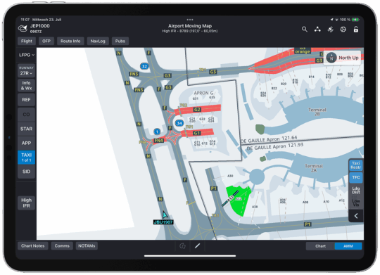
Taxiway restrictions for a 787-9 at LFPG.
How Wingspan Restrictions works
Wingspan Restrictions is built into Airport Moving Maps for Jeppesen FliteDeck Pro.
Jeppesen pulls data from global AIPs, including airport-specific regulations and NOTAMs. When you enter your aircraft model and series, Airport Moving Maps overlays this data directly onto your route, marking restricted areas in red—whether that’s an entire taxiway, a tight turn or a gate not suited to your wingspan.
The best part? No need to manually dig through charts during taxi. It’s all automated and delivered right to your cockpit display—clear, intuitive and up to date.
Why Wingspan Restrictions matter
“Alright,” you might be thinking, “This sounds nifty, but is it really necessary?”
Absolutely. Here’s why:
1. Prevention of proximity hazards
This one tops the list for a reason.
Airports like LAX or CDG are full of intersecting taxiways, tight turns and parking areas that make things complicated fast—especially when multiple widebodies are in motion.
Wingspan Restrictions eliminate the guesswork by visually flagging unsafe routes. For example, taxiing from a maintenance hangar to a remote stand? The system will alert you if your wingspan exceeds clearance at any intersection or entry point—helping you avoid clipping wingtips or breaching safety margins.
No more “I hope ATC is right and I squeeze through there” moments. You’ll feel reassured before you even release the brakes.
2. Compliance with airport regulations
Every airport has its own wingspan rules. Some limit certain taxiways to narrow-body aircraft. Others impose restrictions due to construction, temporary hazards or surface conditions.
Wingspan Restrictions ensure you’re compliant—by dynamically updating your map based on your location and destination. That means a much lower risk of accidentally entering an area designated for smaller aircraft.
You avoid delays, hold-ups and worst-case-scenario violations—all before they happen.
3. Enhanced situational awareness in complex operations
Think of the last time you taxied at a busy international airport with construction zones, innumerous NOTAMs and reroutes happening on the fly. Now add low visibility or nighttime conditions.
With Wingspan Restrictions, your map adapts to the situation—clearly showing which paths are safe for your aircraft and which aren’t. It’s like having a built-in spotlight on your taxi route, helping you stay safe and stay ahead, even in unfamiliar or chaotic conditions.
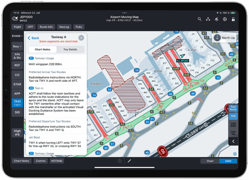
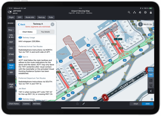
Taxiway A at EHAM, depicting restricted turns for a 787-9.
Real-world example of Wingspan Restrictions in action
Picture this—You’re flying a widebody enroute to a remote gate at an unfamiliar airport. It’s peak traffic, and ATC gives you a slightly unconventional route to avoid a bottleneck.
Normally, that might trigger internal doubts: “Is that taxiway wide enough for me?”
But with Wingspan Restrictions enabled, you immediately see whether that routing meets your aircraft’s clearance limits. No second-guessing. No panicked call to verify. And if you spot a conflict ATC didn’t catch? You can calmly reference the restriction and request a revised route—no delays, no risks, no drama.
Why Wingspan Restrictions simplifies life for pilots
Having dynamic, aircraft-specific routing guidance changes the game, plain and simple. Here’s why pilots love it:
Saves time: Whether navigating a busy ramp or turning around quickly, knowing where you can and can’t go shaves minutes off every leg.
Reduces stress: Clear visual cues mean less second-guessing and fewer moments of relying solely on radio updates.
Supports safety: Fewer encroachments, better compliance and fewer ground incidents across the board.
Closing thoughts
At the end of the day, Wingspan Restrictions in Airport Moving Maps are practical, pilot-first tools that make your job safer, simpler and more predictable.
They give you what static charts and standard moving maps can’t: dynamic, aircraft-specific guidance that adapts in real time to your aircraft, your route and the realities of the airport surface.
Whether you’re at a major international airport or your local hub, this feature ensures you’re always in the know—and always making the safest, smartest moves.
Think of it as just one more way Airport Moving Maps is using smart technology to take ground ops to the next level—one taxiway at a time.