How Low Visibility Depiction in Airport Moving Maps improves pilot operations
You know the drill—taxiing at an airport blanketed in thick fog, or creeping along a downpour-soaked ramp where the runway lights barely cut through the gloom. Low-visibility operations are challenging even in the best conditions—but they don’t have to be a guessing game.
Enter Airport Moving Maps Low Visibility Depiction, a feature built to take the stress out of poor weather taxiing by showing you exactly what you need to know—and avoid—when visibility is reduced and your outside view is nearly nonexistent.
Think of it as having an extra set of eyes in the cockpit, cutting through the haze to help you stay compliant, confident and on course. You’ll know where to turn, when to hold short and how to stick to the safest route—without second-guessing.
What Is Low Visibility Depiction in Airport Airport Maps?
At its core, the Low Visibility Depiction feature is about tailored clarity. By adapting the map to highlight key visual aids and designated taxi routes for low-visibility conditions, it provides pilots with a roadmap that’s easy to follow—even when your outside view is anything but.
You’ll see crucial details like:
Centerline lighting
Low-visibility taxi routes
Route direction and arrows
Hold-short points
Restricted taxiways
All of it optimized to help you move safely and efficiently, even when weather is doing its worst.
How does Low Visibility Depiction work?
When visibility drops below standard operating thresholds, pilots simply select the current visibility conditions within Jeppesen FliteDeck Pro. Airport Moving Map automatically updates, adjusting the visual display to reflect local low-visibility procedures.
That might include:
Highlighting special low-vis routes
Marking closed taxiways
Emphasizing taxiway lights or remaining RVR (Runway Visual Range) limits
And because this is seamlessly integrated into FliteDeck Pro, you’re not fumbling with extra apps or charts. It’s all right there on your EFB, where you’re already used to working.
The benefits of Low Visibility Depiction for pilots
Low visibility turns even routine taxi operations into high-stakes moments. The Low Visibility Depiction feature helps offload that pressure with tools designed specifically to help you stay focused, safe and ahead of the curve.
1. Enhanced situational awareness
The biggest challenge in low vis isn’t just “Where am I?”—it’s “How do I get to where I’m going?” One wrong turn in poor visibility—especially at an unfamiliar or high-traffic airport—can cause delays, confusion or worse.
With Low Visibility Depiction, your airport map shows only what matters:
Your real-time position (ownship)
Illuminated centerlines
Hold-short points
Restricted and active taxiways
Route direction and arrows
No more relying on intuition or squinting through the haze. Everything’s clear, clean and right where you need it—on your cockpit display.
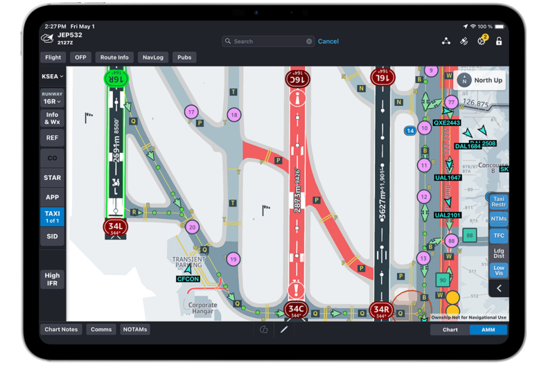
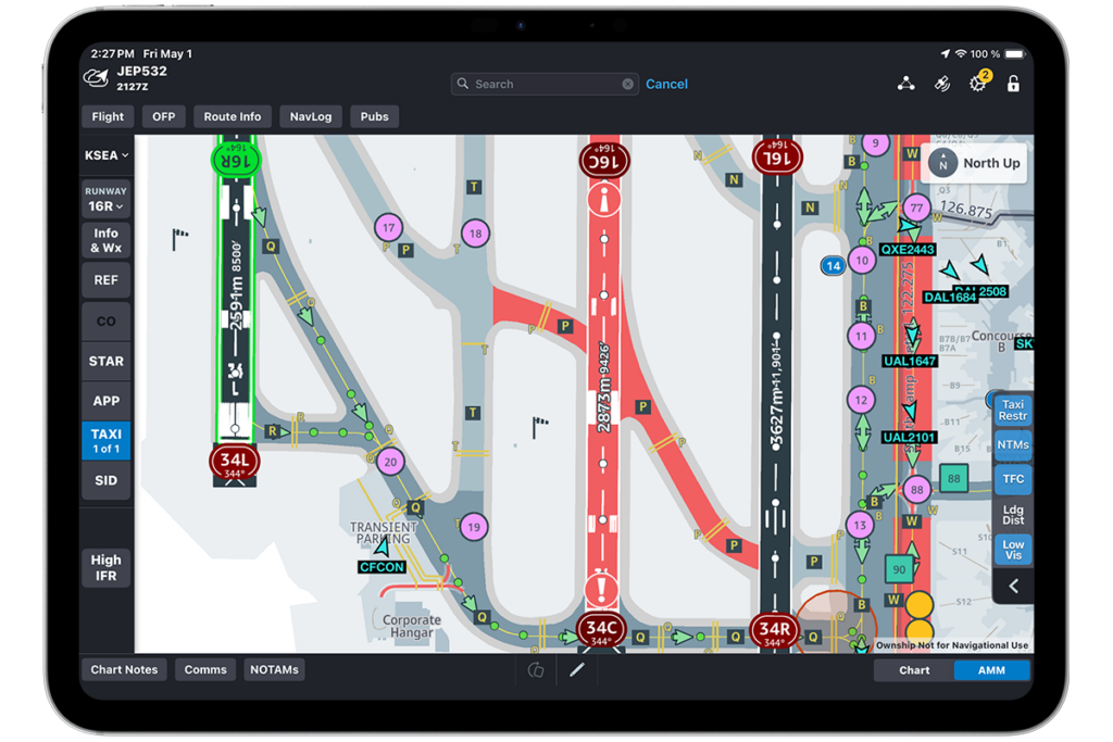
Taxiways during low visibility conditions at SEA.
2. Improved compliance with ATC instructions
When ground control fires off a string of rapid instructions in poor weather, it’s easy to miss something. Low Visibility Depiction bridges that gap by highlighting approved low-vis routes, so you can stay compliant without second-guessing.
You’ll always know where you’re cleared to go—and more importantly, where not to go—with restricted zones and deviations clearly marked.
3. Faster, safer ground movement
Let’s face it—low visibility slows everything down. And while safety comes first, efficiency still matters. With a real-time, route-focused map in front of you, you can:
Avoid unnecessary stops
Cut down time spent idling at intersections
Move confidently from point A to point B
It won’t shave off hours, but those saved minutes can make a big difference—especially when you’re managing fuel burn and time-sensitive operations.
Real-world scenarios with Jeppesen Airport Moving Maps
Sometimes, the best way to understand the value of a feature is to see it in action. Here’s how Low Visibility Depiction proves its worth when the weather’s working against you:
Taxiing amid morning fog
You’re prepping for an early-morning departure from Chicago O’Hare. Fog has visibility down to just a few hundred meters. Normally, taxiing to your departure runway might involve flipping through a myriad of low-vis charts and relying on memory.
But with Low Visibility Depiction active, Airport Moving Map automatically highlights the compliant taxi routes in use. You’re assigned taxiways Alpha and Uniform, and your display shows the correct one-way flow—no need to guess or switch between charts. You follow the highlighted path with confidence, avoiding unnecessary stops, errors and delays.
Navigating in snowbound conditions
Think Denver in winter—snowplows crisscrossing the ramp, faded markings under a blanket of snow and restricted taxiways everywhere.
With Low Visibility Depiction, your map instantly shows which taxiways remain open, which are restricted and where deicing crews are operating. No need to consult multiple low-vis references with each winter storm—your EFB tells you everything in one place.
Why Low Visibility Depiction in Airport Moving Maps raises the bar for pilots
What makes Low Visibility Depictions such a standout is its smart adaptability. It doesn’t just hand you more data—it filters and prioritizes information based on changing conditions and your specific needs. Here’s why it’s ahead of the curve:
What sets Low Visibility Depiction in Airport Moving Maps apart is that it doesn’t just flood you with more data—it adapts intelligently to live conditions and your specific operational environment. Here’s why it leads the pack:
Tailored guidance: Different airports have different procedures for reduced visibility operations, but this feature automatically adapts to local guidelines and limitations, cutting down the learning curve in unfamiliar settings.
Real-time relevance: Adapting to live conditions (think shifting RVR values) ensures you’re always looking at the right information.
Integrated simplicity: No need to flip through different low vis charts. It’s all right on your Airport Moving Map in FliteDeck Pro. The same place you’ll find all the other key information about the airport—and your flight.
Final thoughts
Low visibility doesn’t have to mean high stress. With Low Visibility Depiction in Airport Moving Maps, you gain a level of clarity and control that helps you stay safe, compliant and efficient—no matter what the weather throws at you.
Whether you’re facing fog in Amsterdam or snow-covered ramps in Chicago, this feature is your first line of defense when things get murky. It takes an inherently complex part of flying and makes it manageable—so you can focus on what matters most: getting your passengers and crew safely to their destination.
Fly safe, stay sharp and keep those centerlines in sight—whatever the weather has planned.