Managing aviation data is hard work. Charts change. Airport statuses shift. Company notes need updating. And all of that information has to reach the right pilot, in the right flight context, at exactly the right time. When it doesn’t, you get delays, confusion and unnecessary risk.
That’s the problem Jeppesen Ground Controls sets out to solve. Instead of managing separate applications and chasing updates across email, text and messenger apps, ground operations staff get one unified, web-based suite to handle it all. The result? Smoother operations, less heads-down time for pilots, and a back office that runs on a single source of truth.
In this blog, we’ll walk through what Ground Controls actually does, explain its modules, look at the benefits and explain the four configurations available. By the end, you’ll have a clear picture of how it fits into modern flight operations.
But, what exactly is Jeppesen Ground Controls?
Jeppesen Ground Controls is a web-based application built for commercial airline ground operations. It lets your team create, revise, update, preview, publish and synchronize company enroute data, navigational charts and tailored maps from a single place. It combines several modules into a single suite, helping airlines distribute the right information to pilots quickly and securely.
The core idea is integration. Ground Controls pulls together previously separate software applications into one suite. That means less switching between tools, fewer chances for error and far more control over what pilots see and when they see it.
Because it runs in a web browser, there’s nothing complex to install. The interface uses responsive design, so it works across a range of devices to keep the workflow intuitive enough that most staff need minimal training to start.
What are the key modules in Ground Controls?
Ground Controls brings together several modules in a single suite. Each handles a specific part of the data and charting workflow, and together they cover everything from tailored maps to backup navigation.
Tailored Maps: keeping pilots and ground crews in sync
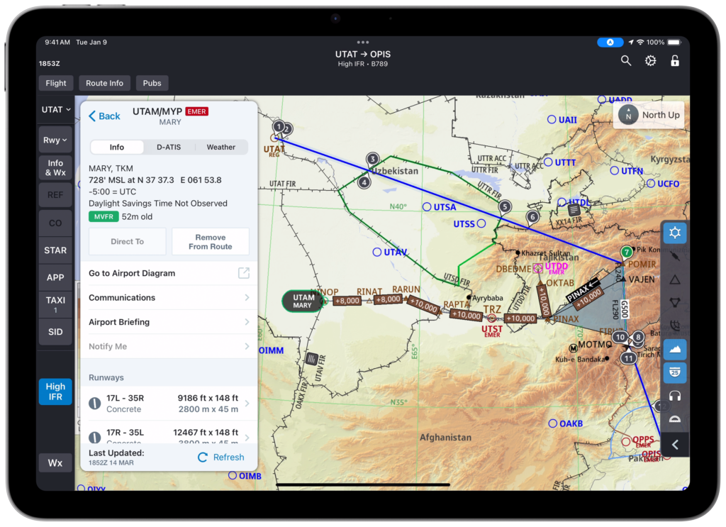
Tailored Maps lets ground operations supplement Jeppesen’s dynamic enroute data with company-specific information for viewing on pilots’ mobile EFB (Electronic Flight Bag) devices. Think fleets, ETOPS (Extended-range Twin-engine Operations) range rings, company airports, location-based communications, custom waypoints, reference boundaries and enroute procedures like decompression, escape and diversion routes.
Diversion Route Rendered on FliteDeck Pro
The big advantage here is freedom from the 28-day revision cycle. Ground operations can send date-specific or real-time updates whenever they’re needed. So, when an airport status changes or a company note has to go out, your team can update it in minutes and push it straight to FliteDeck Pro, in the right flight context. Pilots never have to leave the app to find it, and everyone works from the same data.
Inserted Charts: your charts, on your EFB
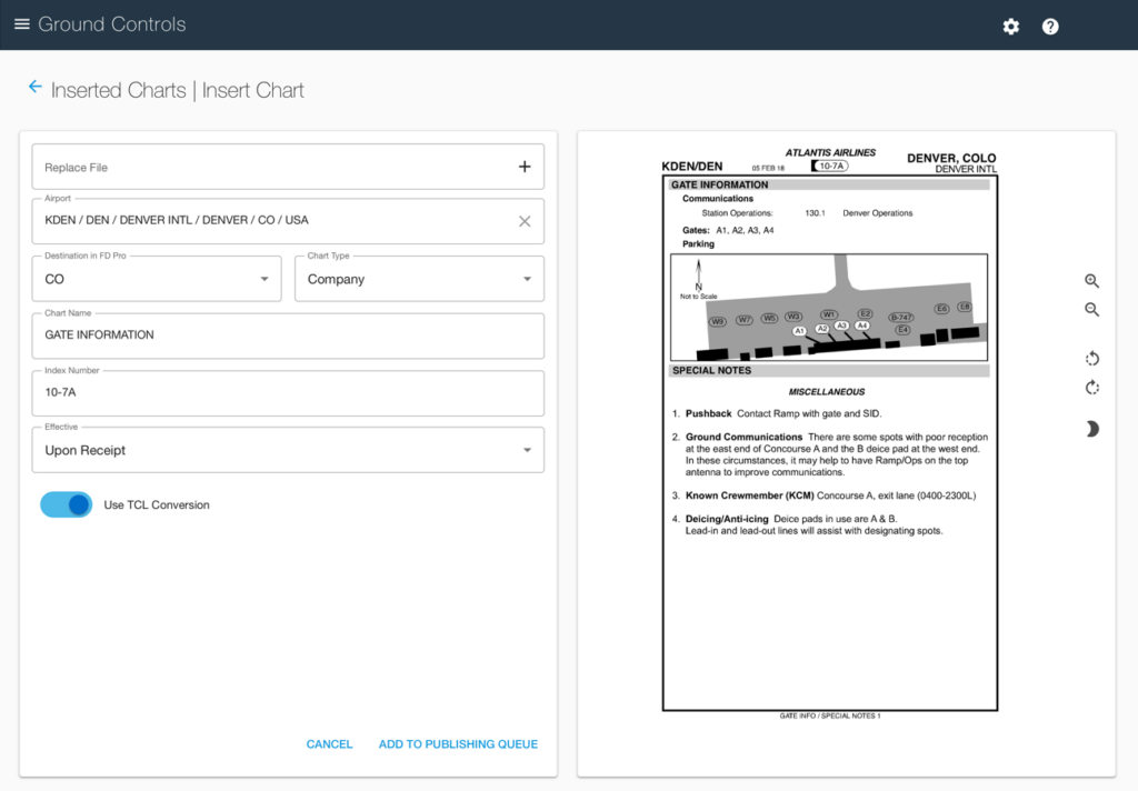
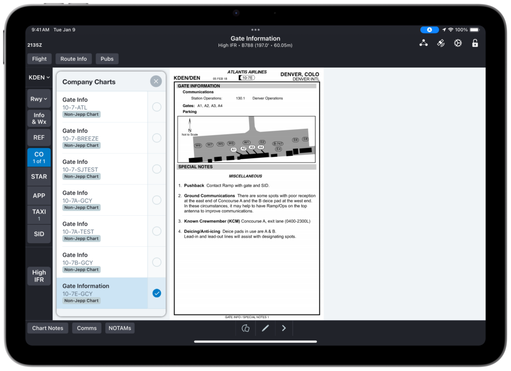
Customer Inserted Charts (CIC) lets you add company-owned charts by airport so pilots can view them alongside Jeppesen charts on mobile EFB devices, in real time. It’s ideal for airlines that maintain their own charting content and want it displayed right where pilots expect it.
Customer-Inserted Chart
The module converts PDF charts and multi-page files into a format viewable in day or night mode. You can insert content into a specific category in alignment with FliteDeck Pro (Approach, Taxi and so on), compare original PDFs side-by-side with inserted content before publishing and push that content to FliteDeck Pro, Trip Kit and Chart Viewer simultaneously. Because you create and distribute everything in-house, you also keep tighter control over information security.
Customer Inserted Chart displayed on FliteDeck Pro
Chart Viewer: preview and check before you publish
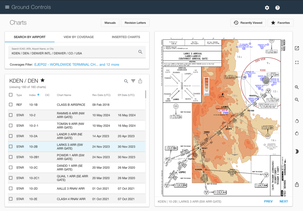
Chart Viewer lets you display Jeppesen, company and inserted terminal charts directly in your web browser. You can view charts in day or night mode, search by airport ICAO (International Civil Aviation Organization), IATA (International Air Transport Association), city or airport name and filter, group, zoom, pan, and rotate as needed.
Searching Charts by Airport
This module is all about confidence. By reviewing your customized navigation data alongside Jeppesen’s charts, your team can review discrepancies quickly and make informed decisions before anything reaches a cockpit.
Trip Kit: an always-on backup for EFB navigation
Trip Kit is a real-time, always-on backup for mobile EFB navigation applications and data. For an entered route of flight, it creates a complete set of charts (standard and tailored) sufficient to push back and fly any IFR (Instrument Flight Rules) flight.
If a pilot’s mobile app or its data becomes unavailable, Trip Kit keeps the fleet moving. Pilots simply access their charts from any connected device through a web browser. That kind of redundancy means fewer disruptions and a lot more peace of mind.
Notifications: the right alerts, not all of them
Notifications provides filtered Chart and NavData alerts to your back office. This enables your back office team to receive Chart and NavData alerts specific to your geographic coverage. Each alert arrives with the relevant details and replacement charts.
Rather than reviewing every alert, your staff see only what matters for their planned flights. That focus helps teams prioritize labor resources, respond faster and stay on top of the updates that actually affect operations.
What are the benefits of using Jeppesen Ground Controls?
Beyond the individual modules, Ground Controls delivers several broader advantages for airline operations:
Simplified operations: Manage data distribution and reviews with one application.
Reduced training: A simple, intuitive interface and workflow means staff learn quickly.
Increased flexibility and efficiency: Create, publish and distribute data, charts and tailored data on-demand or date-specific.
Consistent information: Synchronize data across all platforms at once, so everyone sees the same thing.
Less pilot heads-down time: Supplement enroute data with company-specific content in one place, improving situational awareness.
Enhanced security: Create and distribute customized content in-house, reducing reliance on third parties.
Fewer disruptions: Give pilots immediate access to backup navigational charts when they need them.
There’s also a financial upside. Publishing on your own schedule supports more direct routes and better fuel efficiency, faster responses to scheduled and non-scheduled changes and lower distribution costs through self-service content capabilities.
Which Ground Controls configuration is right for you?
Ground Controls comes in four configurations, so you can match the suite to your operational needs. Here’s a quick overview:
Essential: A comprehensive solution for basic ground operations and data management. Ideal for small to medium-sized airlines, with standard integration, support and industry-standard security.
Preferred: Advanced features for complex operations and enhanced data insights. Suited to medium to large airlines, regional airlines and cargo operators, with priority support and advanced reporting.
Prime: A high-performance solution for demanding operations. Built for major international airlines and large airlines, with 24/7 premium support, and enterprise-grade scalability.
Tailored Enroute Advanced Services: A tailored solution for organizations with unique operational needs or specific regulatory requirements, including deep integration, bespoke reporting and tailored security.
The differences span feature sets, scalability, integration, support, analytics, security and pricing. Choose Essential if you need solid core functionality at a small to mid-scale. Upgrade to Preferred or Prime as traffic, complexity and analytics needs grow. And opt for Custom when off-the-shelf options can’t meet specialized or regulatory demands.
Why Ground Controls matters for modern flight operations
Jeppesen ForeFlight’s vision is to build the most unified, intuitive and innovative aviation platform. Jeppesen Ground Controls fits squarely into that goal. By bringing data management, charting and distribution into one web-based suite, it removes the friction that comes from scattered tools and disconnected workflows.
For airlines already using advanced EFB solutions like FliteDeck Pro, Ground Controls acts as the back-office engine that keeps cockpit information accurate and current. Pilots get company-specific data exactly where they expect it, ground crews publish updates without waiting for revision cycles and everyone shares the same picture in real time.
That shared knowledge is what builds trust between pilots and ground operations, and it’s what helps an entire operation make smarter, faster decisions.
The bottom line on Jeppesen Ground Controls
Jeppesen Ground Controls gives airline ground operations one web-based home for managing, supplementing, previewing, publishing and synchronizing company enroute data, navigational charts and tailored maps. Its key modules (Tailored Maps, Inserted Charts, Chart Viewer, Trip Kit and Notifications) cover the full workflow, while four configurations let you scale the suite to your needs.
The payoff is real: greater efficiency, stronger security, fewer disruptions and better decision-making across your operation. If you’re ready to take control of your data, explore Jeppesen Ground Controls by reaching out to the Jeppesen ForeFlight team.
Frequently asked questions
What is Jeppesen Ground Controls used for?
Jeppesen Ground Controls is used by airline ground operations to manage, supplement, preview, publish and synchronize company enroute data, navigational charts and tailored maps. It distributes company-specific content to pilots’ EFB devices and provides backup navigation, all from a single web-based application.
What modules are included in Ground Controls?
Ground Controls includes the following key modules: Tailored Maps, Inserted Charts, Chart Viewer, Trip Kit and Notifications. Together they handle custom enroute data, company charts, chart review, backup navigation and geographically filtered chart and navdata alerts.
What are the four Ground Controls configurations?
The four configurations are Base, Enterprise, Pro and Custom. Base suits small to medium operations, Enterprise serves medium to large airports and regional carriers, Pro targets major airlines and international airports and Custom is tailored to unique operational or regulatory requirements.
Do I need to install software to use Ground Controls?
No. Ground Controls is a web-based application that runs in a web browser, so there’s nothing to install. It supports browsers such as Microsoft Edge, Chrome, Firefox and Safari, and uses responsive design for viewing across different devices.
How does Ground Controls improve flight safety?
Ground Controls improves safety by keeping pilots and ground crews on the same, up-to-date data. Real-time updates reduce missed information, Trip Kit provides backup charts if a pilot’s app fails and Notifications ensure teams act on the alerts most relevant to their operations.