Flight Deck in Focus: Managing GPS Interference during Enroute Operations
Somewhere over the Eastern Mediterranean, a flight crew watches the map position drift off the airway. The FMS is confident: it commands a turn to intercept a track that a second ago was directly beneath the aircraft and is now 200 miles to the right. The displays are clean. Nothing has failed — and that is precisely the problem.
GPS interference has moved from an edge case to a routine challenge with international operations. OPSGROUP’s 2024 workgroup tracked spoofing events rising from roughly 300 affected flights per day in early 2024 to about 1,500 per day by that August, with 41,000 flights affected in a single month. IATA’s 2025 Safety Report recorded a 67% increase in reported jamming and a 193% increase in reported spoofing between 2023 and 2025. The hotspots are well known: the Eastern Mediterranean, the Black Sea, the Baltic, the Middle East, and parts of South Asia.
Most of it is not aimed at civil aviation — it is spillover from counter-drone activity and defense against GPS-guided munitions. But interference does not respect FIR boundaries: a transmitter defending a coastline can degrade navigation for every airway within hundreds of miles.
Why GPS interference matters now
The cost of interference is usually accumulated workload and delay rather than a single dramatic event — until it removes a route from the network entirely. In April 2024, Finnair suspended its Helsinki–Tartu service for a month after two flights had to return: the only approaches available at Tartu were GNSS-based, leaving no interference-independent way in.
When a crew loses GPS integrity without warning, the flight deck shifts into diagnosis mode at cruise: cross-checking IRS against radio position, reverting to conventional navaids, and coordinating with ATC on an airway where several other aircraft are doing the same thing. Spoofing is the harder problem, because the receiver is not silent — it is confidently wrong. Position and time can be corrupted while the display looks entirely normal, or spurious EGPWS alerts can distract an already busy cockpit.
The effects compound downstream: reactive rerouting burns fuel that was never in the release, holding and vectoring consume schedule margin, and contaminated position or time data can require maintenance action before dispatch. In an OPSGROUP survey of around 2,000 crew, close to 70% rated the safety impact of spoofing as very high or extreme.
Crews have the training and the procedures to handle degraded GNSS. What they typically lack is the knowledge that they are about to fly into it.
The solution: seeing interference before you enter it
Jeppesen Enroute Intelligence brings GPS jamming and spoofing information directly onto the Jeppesen FliteDeck Pro enroute map, so interference-prone airspace is something crews plan around rather than diagnose in flight.
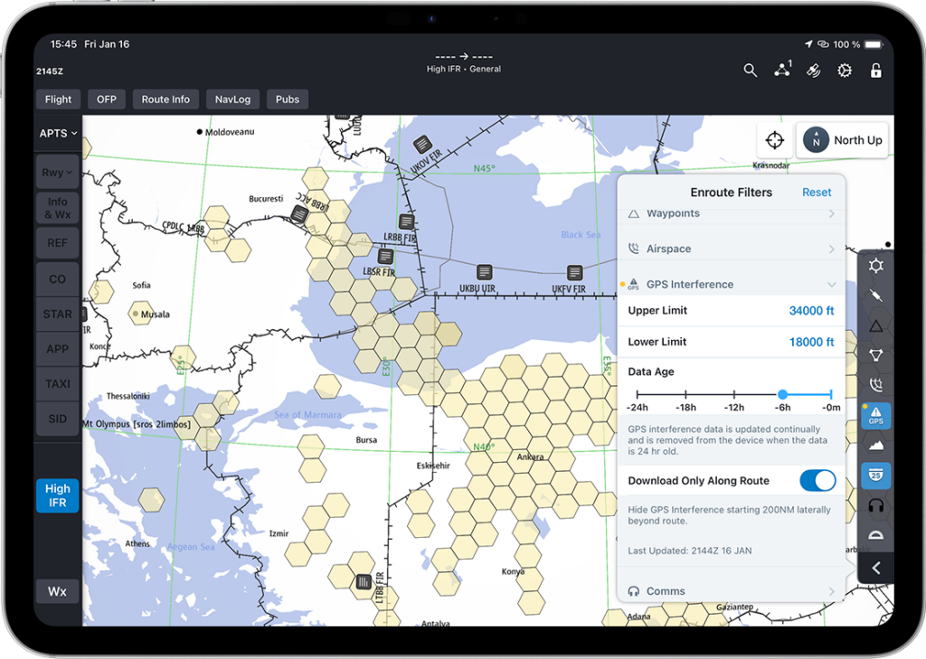
The GPS Interference layer renders affected areas as map objects on the same enroute display the crew is already using — not in a separate advisory document, and not as a NOTAM string to be decoded. If the route clips a known interference area, the crew sees it in geographic context — airway, FIR boundaries, and alternates on the same picture. Filtering keeps that picture clean, so the map shows the areas that matter to this route and this phase of flight rather than every reported event worldwide.
Filtering GPS Interference Layer by Altitude, Data Age, and Route.
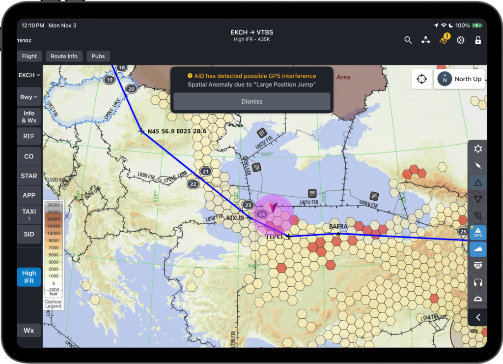
Cross-checking position integrity.
Knowing the aircraft is inside a flagged area changes how the crew interprets what they see. Position anomalies stop being an ambiguous puzzle and become an expected condition with a known response: verify against IRS and ground-based navaids, apply the operator’s degraded-GNSS procedure — on many types, inhibiting GPS updating of the FMS position — and treat GPS-derived data with appropriate suspicion until clear.
Choosing alternatives early.
The most valuable decision is the one made before the aircraft is inside the affected volume. With interference areas visible during planning, an offset, a different airway, or a coordinated reroute can be requested while the flight still has fuel and time to spend on it.
It does not stop at top of descent.
Cruise is where interference is most often encountered, but it is not where it costs the most. Departure and arrival are where a degraded position source meets tight terrain, tight airspace, and no time to think. RNP departures, approaches down to LNAV/VNAV and LPV minima, and RF legs through terrain all assume a position the aircraft can trust. When that assumption fails on arrival, the consequences are immediate — an approach that cannot be flown, a diversion, or, as at Tartu, no viable approach at all.
The same awareness that keeps a crew ahead at FL370 lets them arrive with the terminal phase already resolved:
In planning, seeing that the destination or a filed alternate sits inside a reported interference area changes the fuel and alternate decision before the aircraft moves. An alternate that only offers GNSS-based approaches deserves a second look that day.
In the descent briefing, knowing the arrival airport is affected turns the conversation from which RNP approach to which conventional procedure, which navaids, and what that does to minima and fuel.
On departure, the same picture informs whether an RNAV SID is appropriate and what the plan is if position integrity degrades during the climb.
None of this requires new procedures. What changes is when the crew finds out — during the briefing, with options open, rather than at the final approach fix.
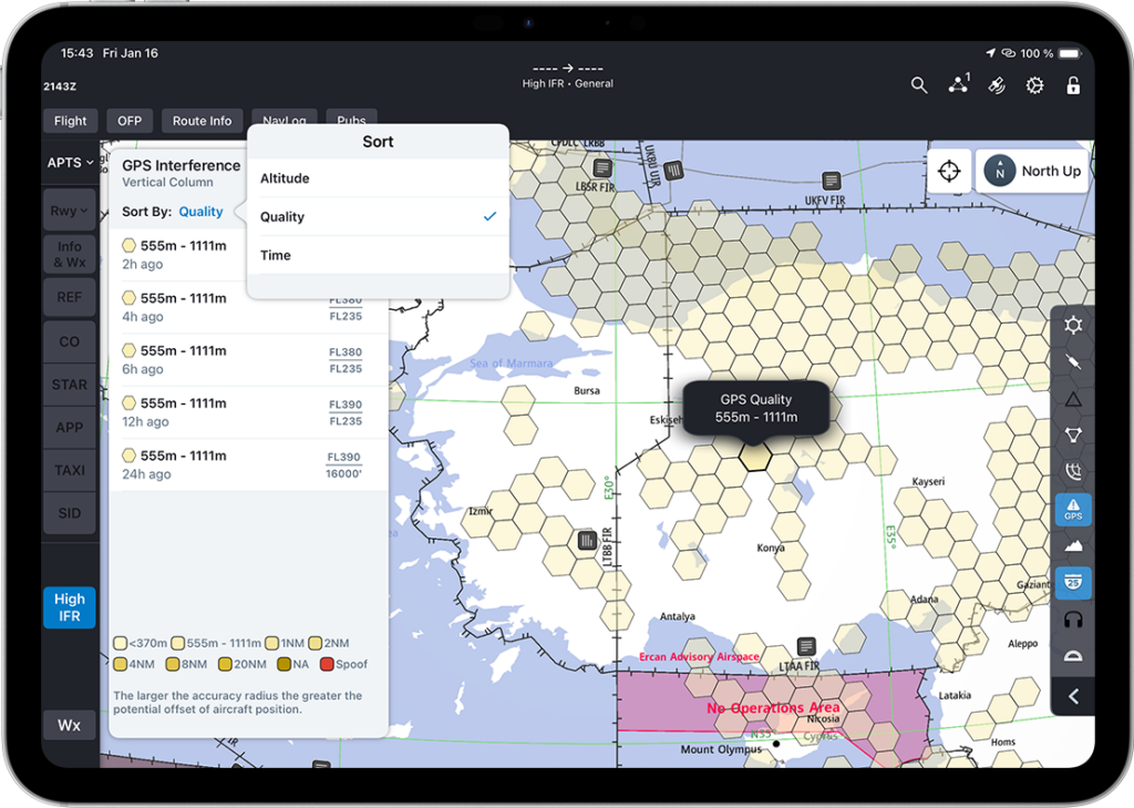
GPS Quality and Interference Visualized along the Enroute Map.
Tying it together
The objective is navigation resilience: keeping the crew ahead of the aircraft in airspace where the primary position source may not be trustworthy — from the SID, through cruise, to the approach.
For crews, that means fewer surprises and a plan that matches the airspace they will actually fly through. For dispatch, it means fewer reactive reroutes and the extra fuel they burn, plus more realistic alternate selection. For the safety organization, it means a lower operational risk exposure: degraded-GNSS events that are anticipated rather than discovered.
Interference is unlikely to disappear from international operations in the near term. What operators can control is whether their crews meet it forewarned or by surprise.
FAQ
What is the difference between GPS jamming and GPS spoofing?
Jamming overwhelms the GNSS signal so the receiver loses it. Spoofing transmits false signals so the receiver produces incorrect position or time while appearing to function normally.
Where is GPS interference most common?
Reported activity concentrates around conflict zones — most notably the Eastern Mediterranean, the Black Sea, the Baltic region, the Middle East, and parts of South Asia.
Does GPS interference affect approach and departure as well as cruise?
Yes. RNAV and RNP procedures depend on a trusted position source, and airports served only by GNSS-based approaches can become unusable during an interference event.
How does FliteDeck Pro show GPS interference?
Jeppesen’s Enroute Intelligence Pack displays jamming and spoofing areas as a filterable layer on the enroute map in FliteDeck Pro, so crews can see affected airspace relative to their route during planning and in flight.
How do I get Enroute Intelligence for FliteDeck Pro?