Navigating GPS interference with Jeppesen FliteDeck Pro v5.2
Global Positioning System (GPS) technology is a critical resource for aviation, serving as the primary navigational framework for modern aircraft. For the vast majority of commercial flights, satellite navigation networks function flawlessly to guide aircraft safely across complex global airspace systems. However, intentional and unintentional disruptions to these signals present a growing concern within the aviation industry, with the frequency and scale of interference events trending continuously upward.
Low-power GPS satellite signals are inherently vulnerable to intentional malicious actions, which typically occur in regions in/near active conflict zones. But atmospheric conditions and unauthorized ground-based transmitters can also unintentionally disrupt GPS signals. As these disruptions escalate in both sophistication and frequency, flight crews require highly reliable, dynamic tools to anticipate and navigate affected airspaces safely.
To address this complex operational challenge, the latest release of Jeppesen FliteDeck Pro, version 5.2, incorporates a dedicated enroute map overlay designed specifically to highlight areas of known GPS interference. By integrating Flightradar 24 data and advanced algorithms, this enhanced visualization equips pilots with the actionable intelligence required to maintain situational awareness and support safe, continuous operations.
What is GPS interference?
GPS interference is generally categorized into two distinct forms: jamming and spoofing.
GPS Jamming
Signal jamming occurs when navigational receivers are saturated with powerful, unknown radio frequencies, rendering the equipment temporarily unusable. By overpowering the legitimate satellite signals, jamming effectively degrades the ability of an aircraft to determine its precise geographic position. This interference is frequently generated by illegal devices used to mask the locations of terrestrial vehicles, though it is also deployed on a much larger scale in specific geopolitical hotspots. While jamming generally triggers immediate alerts within the cockpit, prompting flight crews to revert to secondary navigational instruments, the loss of primary GPS data inevitably increases pilot workload.
GPS Spoofing
Spoofing is widely considered to present a significantly greater threat to flight safety due to its inherently deceptive nature. Unlike jamming, which simply blocks the signal, spoofing involves the deliberate transmission of look-alike satellite data. The aircraft’s GPS navigation system quietly accepts the false signal, calculating an erroneous position or time without immediately triggering system alarms. Consequently, spoofing can generate wide-ranging cascading effects across various avionics systems, including the Flight Management System (FMS) and Terrain Awareness and Warning System (TAWS). If left undetected, severely degraded pilot situational awareness could lead to course deviations or unauthorized airspace incursions.
How does FliteDeck Pro help with GPS Spoofing and Interference?
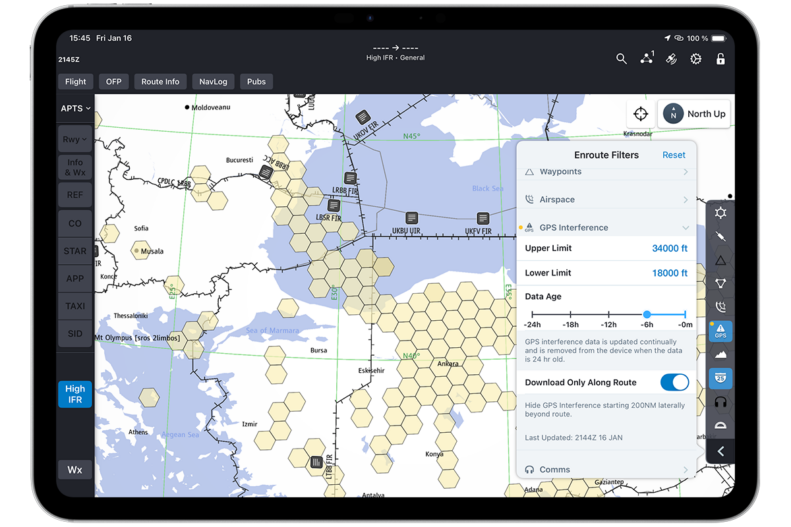
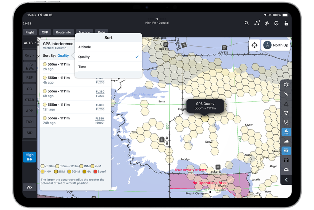
Within the FliteDeck Pro interface, detected GPS interference zones are overlaid directly onto the enroute map using highly visible colored voxels, or hexagonal data bins. Red voxels are utilized specifically to indicate areas where potential spoofing has been detected. The presentation of these red voxels is not intended as a strict prohibition against entering the designated airspace; rather, it serves as a critical advisory that spoofing activity has been recorded.
Different color shades are applied to indicate varying degrees of generalized signal interference. Furthermore, individual voxels can be tapped by the pilot to view detailed granular data, and various filtering and sorting options can be applied to customize the display based on airline-specific standard operating procedures.
FliteDeck Pro helps improve situational awareness by showing areas of GPS interference.
Optimize your commercial flight operations with Jeppesen ForeFlight
The complexities of modern aviation demand robust, data-driven solutions that protect against electronic operational hazards. By visualizing complex GPS interference data directly within the navigational interface, flight crews are empowered to make highly informed, proactive decisions regarding their routing and aircraft navigation system reliance.
FliteDeck Pro provides commercial aviation pilots with the comprehensive navigational charts, manuals, and real-time situational awareness tools needed for flying, all delivered in one intuitive pilot-focused interface.
Ready to experience it? Contact our sales team to see how FliteDeck Pro will help your pilots’ situational awareness when it comes to areas of GPS interference.